Bryce Canyon & Ruby's Inn History
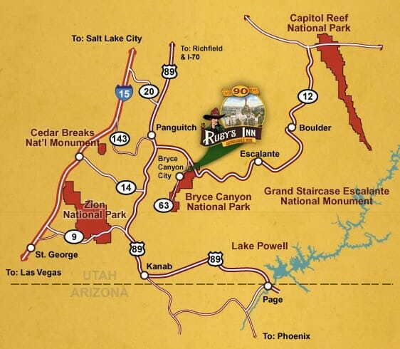
The map is a basic overview of the area surrounding Ruby's Inn & Bryce Canyon. For a more detailed map of the area, click here for online web viewing.
If you want to familiarize yourself with our facilities, take time to look at the Ruby's Inn illustrated map.
When traveling to Bryce Canyon Natonal Park from I-15, use Highway 9 through Zion National Park, or Highway 143 through Brian Head Ski Resort (spring, summer, fall only), or Highway 20.
If you need a little help getting to us, please call 866-866-6616.
Mileage Chart for Bryce Canyon National Park
- Brian Head - 56 Miles
- Cedar City - 97 Miles
- Panguich Lake - 22 Miles
- Capitol Reef National Park - 120 Miles
- Lake Powell - 141 Miles
- Las Vegas, NV - 271 Miles
- Grand Staircase - 26 Miles
- St. George -125 Miles
- Salt Lake City - 260 Miles
- Zion National Park - 72 Miles
- Car Rental
Directions
Travel North on Interstate 15 past St. George and Cedar City. Travel 35 miles past Cedar City to exit #95 (Right Turn) to State Highway 20. Follow Highway 20 (19 miles) to Highway 89. Turn Right (South) to the town of Panguitch. In downtown Panguitch turn left to stay on highway 89. Follow road East and then South to Highway 12. Turn left and travel East (13 miles) to Highway 63. Turn right on Highway 63 and travel one mile to Ruby's Inn. The entrance to Bryce Canyon is just one more mile down Highway 63.
When traveling to Bryce Canyon National Park from I-15, use Highway 9 through Zion National Park, or Highway 143 through Brian Head Ski Resort (spring, summer, fall only), or Highway 20.