Bryce Canyon National Park Information
Visiting Bryce Canyon National Park
Bryce Canyon National Park is one of the most distinctive landscapes in the American Southwest, known for its thousands of colorful hoodoos and sweeping canyon views. Located in southern Utah along the edge of the Paunsaugunt Plateau, the park is made up of a series of natural amphitheaters filled with spires, fins, and cliffs shaped over thousands of years.
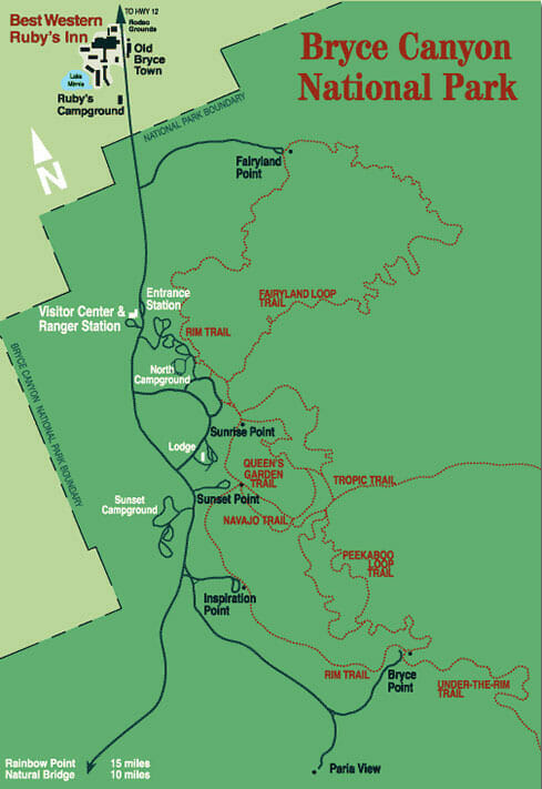
Staying at Ruby’s Inn places you just outside the park entrance, making it easy to explore Bryce Canyon early in the morning, take a break during the day, and return for sunset without long drives.
Bryce Canyon Overview
- Location: Southern Utah near Bryce Canyon City
- Elevation: 8,000 to 9,000 feet
- Known For: Hoodoos, amphitheaters, and scenic viewpoints
- Best Time to Visit: Spring through fall for full access, winter for fewer crowds
- Time Needed: Half day to full day for most visits
What Makes Bryce Canyon Unique
Bryce Canyon is often described as a canyon, but it is actually a series of amphitheaters carved into the plateau. The hoodoos that fill these formations are created as softer rock erodes faster than the harder layers above it.
Water and ice play the largest role in shaping the landscape. As moisture seeps into cracks and freezes, it expands and gradually breaks apart the rock in a process known as frost wedging. Over time, this creates the narrow, towering formations that define Bryce Canyon. Wind contributes at a much slower rate, which is why the landscape continues to evolve gradually
History of Bryce Canyon and Ruby’s Inn
Bryce Canyon is named after Ebenezer Bryce, a pioneer who settled in the Paria Valley in the late 1800s. He built roads and irrigation systems in the area, and the unusual formations near his home became known as “Bryce’s Canyon.”
As more people began visiting, Reuben and Minnie Syrett helped introduce guests to the canyon and developed early lodging and dining facilities. Their efforts played an important role in establishing Bryce Canyon as a destination.
When the area was designated a national monument in 1923, development increased. The Syrett family later built what is now Ruby’s Inn just outside the park boundaries, continuing a long tradition of welcoming visitors to Bryce Canyon.
Top Things to Do in Bryce Canyon
Bryce Canyon offers a mix of scenic viewpoints, hiking, and driving routes that allow you to experience the landscape in a variety of ways.
- Hike along the scenic rim
Start at Sunrise Point, Sunset Point, and Bryce Point for sweeping views of the amphitheaters. These overlooks are especially popular at sunrise and sunset, when the light brings out the color and depth of the rock formations. - Explore below the rim
Hiking into the canyon offers a completely different perspective, allowing you to walk among the hoodoos and better understand their scale and detail. - Drive through the park with scenic viewpoint stops
The park’s main road provides access to additional overlooks and trailheads, making it easy to see different areas of Bryce Canyon in a single visit.
Hiking in Bryce Canyon
Hiking is one of the best ways to experience Bryce Canyon, allowing you to explore beyond the main viewpoints and see the formations up close. Trails range from short, accessible routes to longer, more strenuous hikes.
Some of the most popular options include:
Getting Around Bryce Canyon
During peak seasons, Bryce Canyon operates a shuttle system that stops at major viewpoints and trailheads. Using the shuttle can help reduce traffic and make it easier to access popular areas.
You can find Bryce Canyon Shuttle information here.
Visitors can also explore the park by car, particularly during less busy times of the year.
When to Visit Bryce Canyon
Bryce Canyon is open year-round, and each season offers a different experience. Summer is the most popular time to visit, with warm weather and full access to trails and viewpoints. Spring and fall tend to be quieter, with comfortable temperatures for hiking, while winter offers a quieter atmosphere and snow-covered landscapes.
Because of the park’s elevation, temperatures can change quickly throughout the day. Even in summer, mornings and evenings are often cool, so dressing in layers is recommended.
Most visitors spend between half a day and a full day exploring Bryce Canyon, depending on how much hiking and sightseeing they plan to do.
Stay Near Bryce Canyon National Park
Staying near Bryce Canyon allows you to experience the park at its best, especially during early morning and evening hours when lighting and crowds are at their most favorable. Ruby’s Inn is located just outside the park entrance, with dining, activities, and shuttle access all nearby. It’s easy to take a break when needed and head back out without long drives.
Whether you are visiting for a quick stop or a longer trip, Ruby’s Inn offers a comfortable base for exploring Bryce Canyon and the surrounding area.